North China is a typical region in the world where the groundwater level continues to decline. The alarming groundwater depletion has a huge impact on socio-economic stability and sustainable development of this region. To date, numerous researches have estimated groundwater changes in North China based on Gravity Recovery and Climate Experiment (GRACE) satellite data, which can provide powerful support for the formulations of reasonable strategies in groundwater exploitation and utilization. However, the GRACE unconstrained time-variable gravity field models used in most studies contain too much correlated noise at high degrees, so the filtering method must be adopted to suppress the noise, but signal attenuation and leakage is obvious after being filtered, and as a result the spatial resolution of filtered solutions are generally restricted. Furthermore, the driving factors of groundwater depletion in North China still lack effective quantitative analysis, and corresponding mechanism is in urgent need of revealing. Consequently in this study, the gravity field model Tongji-RegGRACE2019 is applied to obtain Groundwater Storage (GWS) change estimation with a higher spatial resolution in North China. Then, Independent Component Analysis (ICA) is used to implement spatiotemporal decomposition for GWS, and the periodic characteristic of each source signal is explored. Finally, the driving factors and mechanisms are accurately determined by Pearson’s correlation coefficient and grey absolute correlation degree.
As shown inFig. 1, the Terrestrial Water Storage (TWS) and GWS from January 2014 to December 2015 estimated by the Tongji-RegGRACE2019 model both exhibit decreasing trends with the rates of -1.00±0.06 cm/yr and -0.87±0.04 cm/yr, respectively. The rate of GWS estimated by Tongji-RegGRACE2019 model is basically consistent with that by the monitoring well during the same period (2005 to 2013), with a correlation coefficient of 0.81 and Root Mean Squared Error (RMSE) of 1.94 cm, indicating that Tongji-RegGRACE2019 model is reliable in describing the water resource changes in North China.
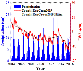
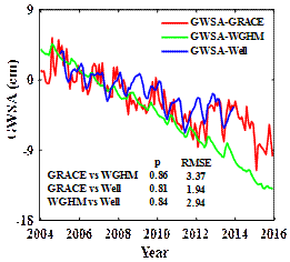
Fig. 1TWS (left) and GWS (right) time series,pdenotes Pearson’s correlation coefficient
The Independent Component (IC) is derived by implementing spatiotemporal decomposition for GWS using ICA method. As shown inFig. 2, the first four ICs, accounting for 89% of the total variance, respectively reflect the intra- or inter-annual cycles of GWS changes located in northern Shanxi, southern Shanxi, southern Hebei and east-central Hebei. Arguably, the temporal component of each GWS-IC is generally less clustered by different time cycles and the spatial pattern shows distinct localized characteristics. By establishing a one-to-one correspondence between the GWS-IC and potential driving factors (Fig. 3), the first and second ICs (IC1 and IC2) cooperatively reflect long-term and intra-annual GWS changes caused by water consumption of coal mining and agricultural irrigation in northern and southern Shanxi province, with the correlation coefficients of -0.91 and -0.85, respectively. IC3 indicates the signal of semi-annual GWS change related to agricultural irrigation water consumption in southern Hebei province, with a correlation coefficient of -0.85. Besides, IC4 suggests the effect of monsoon precipitation and evaporation in front of Taihang Mountain.
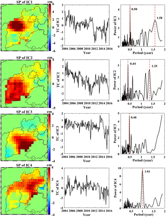
Fig. 2Temporal Component (TC) and Spatial Pattern (SP) of GWS-IC
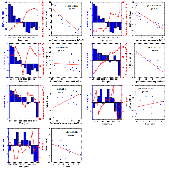
Fig. 3Correlation analysis between GWS-ICs and potential driving factors
According to the intra-annual distribution of GWS time series (Fig. 4), taking July and August as demarcation points, it can be divided into three stages. Among which the rapid depletion of GWS is the combined impact of the coal mining and agricultural irrigation in the first stage (January to July). Subsequently in the second stage (July to August), the sharp recovery of GWS benefits from the replenishment of heavy rainfall, and the irrigation pressure is greatly alleviated. In the last stage, despite the increase in water consumption for agricultural irrigation and coal mining, GWS depletion is limited and shows a slow decreasing trend due to the accumulation of rainfall in the past rainy season. Hence, the driving factors, including uneven spatiotemporal distribution of precipitation, intense seasonal evaporation, severe loss by coal mining, coupled with exhaustive exploitation for irrigation, jointly restrict the GWS rise and fall at different time nodes.
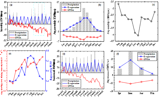
Fig. 4Time series of GWS and driving factors at monthly (a), seasonal (e), average monthly (b, c, d) and average seasonal (f)
The study was published in the ”Journal of Hydrology”, and this work was primarily supported by the National Natural Science Foundation of China (grant numbers 42061134010, 41974002).
Citation:
Feng, T., Shen, Y., Chen, Q., Wang, F., Zhang, X. (2022). Groundwater storage change and driving factor analysis in North China using independent component decomposition. J. Hydrol., 609, 127708, doi: 10.1016/j.jhydrol.2022.127708.